Hiking, Walking Trails, Waterfalls & Wildlife Viewing
See a comprehensive list of hiking areas near Duvall.
See Duvall's Walking Map from Mountains to Sound Greenway
See: A Local Mom, Jennifer Dotson, Easy Hiking with Kids Blog
WA State Dept of Fish and Wildlife: https://wdfw.wa.gov/
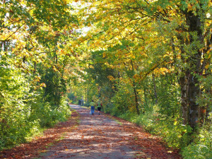
Snoqualmie Valley Trail,  which routes through Duvall’s natural areas, parks and farmland, is a wonderful place for runners, horseback riders and mountain bikers. A family-friendly area, the trail borders the tranquil Snoqualmie River and even traverses an occasional railroad trestle, as it was once the railway for the Chicago Milwaukee Railroad. Avid birders will be thrilled by its abundance of birds, including eagles and falcons.
Before heading out for a family bike ride on the Snoqualmie Valley Trail, check out the new interpretative signage at Depot Park and identify many of the flora and fauna along the way. After your ride, grab a lunch to go from one of Duvall’s many restaurants and enjoy it around the new fire pit at Depot Park. See map.
Most of the trails and areas featured in the Duvall area do not require a special pass or access permit.
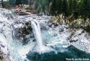
Wallace Falls State Park in nearby Gold Bar is a good long day hike with breathtaking views of several large waterfalls. Located in the foothills of the Cascades with an elevation gain of about 2,000 feet over three miles, this is a harder hike. But you don’t need to go all the way to the top to experience the waterfalls. If you choose, you can stop at the lower or middle falls. WA State Park Discovery Pass required. Click Here for Wallace Falls State Park.
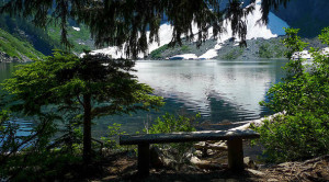
 Index Peak/Bridal Veil Falls/Lake Serene East of Gold Bar, WA in the Mount Baker Snoqualmie National Forest is an amazing yet strenuous hike with 22 switchbacks. As you hike up in elevation, the diversity of the forest is incredible. This hike has many different viewpoints. You can experience Bridal Veil Falls from the bottom or hike your way to the top. If you make it all the way to the top, you’ll find a beautiful alpine lake nestled in between trees and steep mountain walls. Northwest Forest Pass Required. Click Here for information on Index Peak, Bridal Veil Falls and Lake Serene.
Tolt MacDonald King County Regional Park in nearby Carnation, WA is an amazing spot. Within this park is the confluence of the Tolt and Snoqualmie Rivers. Great flat hiking or steep hiking options are available, including a 500-foot suspension bridge across the Snoqualmie River. In the fall, this is a great place to see salmon spawning and watch other wildlife such as bald eagles. This park also offers locations for camping and picnicking. Click here for information on camping and accessing Told MacDonald Park.
Moss Lake Natural Area is a King County Department of Natural Resources and Parks (DNRP) Ecological Land. The site is located 5 miles southeast of Duvall, 3.5 miles northeast of Carnation, and 1 mile east of Lake Joy in the Cascade foothills. The site is comprised of 372 acres of high-quality wetland and forested upland habitats. An extensive Class 1 wetland complex encompasses a large sphagnum bog (heavily moss-filled), beaver dams, open water and forested wetland. Moss Lake NA receives a modest amount of public use. There is a limited (official) trail system on the site, and users include hikers, equestrians and mountain bikers. There is a pit toilet and a parking lot for up to 16 cars or 10 cars and three busses. Most of the trails are outside the park boundary and ownership of the rest is Weyerhaeuser, Hancock, and PSE. The area is defined by the pipeline to the north and Stossel Creek with the Tolt River to the South. Click here for Moss Lake Information. King County information on Moss Lake.
Mount Si, North Bend, WA Well-maintained trails climb great switchbacks up the glaciercarved south side of Mount Si to reach stunning views at the top. The ascent is somewhat technical and can be quite fast if there are not too many people and dogs on the trail. The intermediate to advanced trail runner will get a satisfying workout on this trail. Since it’s an out-and-back trail, beginning runners can use this route for strengthening hill muscles, then turn around when they’ve had enough. This 4167-foot, haystack-shaped mountain juts out of the virtually flat basin and can be easily identified from Interstate 90 and many parts of the Snoqualmie Valley. You can point to the craggy peak of Mount Si from Interstate 90 and say to your friends, “I ran to the top!” The mountain was named for a settler, Josiah “Uncle Si” Merritt. Mount Si has the distinction of being one of the two most-climbed mountains in Washington, the other being Mount Rainier. Click here for information on Mount Si and Little Si hiking.
Activity Type: Trail Running
Nearby City: North Bend
Length: 8 total miles
Elevation Gain: 3,250 feet
Trail Type: Out-and-back
Skill Level: Moderate to strenuous
Duration: 2.5 hours
Season: Year-round, snow sometimes in winter
Top Elevation: 3,900 feet
Local Contacts: Department of Natural Resources Local Maps: Department of Natural Resources Mount Si
Little Si Under the shadow of its bigger brother, Little Si is so tiny, so close. Whether you need a quick hike in the forest after a hard day at the office or an interesting walk with young children, Little Si is a perfect fit. Its accessibility to Seattle makes it more of an urban walk than a wilderness hike, and this popularity is reflected by a wide and beaten down track and a thirty-car parking area with a lot of turnover—and not of the pastry kind. Nevertheless, this is still a very pretty route to take, and views from the top are just as good as from Mount Si—and much less work!
 Snoqualmie Falls Long before the explorers and hop growers reached Snoqualmie Valley, Native American tribes met for trade and council beside the thundering torrent now called Snoqualmie Falls. Early settlers referred to the natives who lived along the riverbanks as the “moon people,” for their name was said to be derived from Snoqualm, meaning “moon.” The first white settlers arrived in 1855. By the early twentieth century, hops, timber, and electrical power that harnessed the falls’ tremendous energy were important segments of the local economy. Today it’s tourism. The scenic valley, just 30 miles east of Seattle, is webbed with quiet back roads that pass farmlands, forests, mountains, and gurgling streams on their way to the Snoqualmie River. This getaway offers both a chance to refresh the spirit and a variety of recreation. Highlights include: a dramatic waterfall, a steam train ride, a luxury resort, golf courses, an herb farm, a winery, bicycling, hiking, and antiques shopping. Click here for information on Snoqualmie Falls. Click here for information on the Salish Lodge and Spa.
Twin Falls – North Bend WA A dramatic series of waterfalls along the South Fork Snoqualmie River, a high bridge over an impressive gorge, and an observation deck aerie are the biggest draws for hiking the Twin Falls Trail. It’s a popular route, especially from the west trailhead, but beginning from the east allows hikers to appreciate a short section of the old Milwaukee Railroad grade and views both up and down the Snoqualmie Valley. Though the trail is wide below the falls, there are no passing lanes. Solitude seekers are advised to begin at the east trailhead, where few venture. Twin Falls is not the only allure to this trail. Anglers will find plenty of way trails down to the river below the falls. Click here for information on Twin Falls.
Wildlife Viewing Three great wildlife-viewing areas in the Snoqualmie Valley include Stillwater, Cherry Valley 203 and Crescent Lake 203. Cherry Valley and Crescent Lake are located along State Route 203 North of Duvall and Stillwater is on SR 203 South of Duvall. All are Washington DNR Wildlife Areas requiring a Discover Pass. These areas are great for wildlife especially bird viewing like pheasants, waterfowl, eagles and hawks. Note that during hunting season, hunters may be in these areas. Moss Lake Natural Area, about five miles southeast of Duvall, is a beautiful wetland surrounded by 372 acres of high-quality habitat, including a sphagnum bog. Because of its rare diversity and protected status, it’s a great place to spot birds like the Vaux’s Swift and Band-tailed Pigeon.
Special thanks goes to The Wilderness Awareness School for providing information about area hiking and wildlife viewing.

Duvall Chamber of Commerce
PO Box 581 Duvall, WA 98019
(425) 788-9182
info@duvallchamberofcommerce.com


